
For centuries, travelers and geologists have marveled at rivers that carve straight through towering mountain ranges instead of taking easier routes around them. These dramatic landscapes—deep gorges, narrow canyons, and winding valleys—often raise a simple but fascinating question: why didn’t the river just flow around the mountain? Thanks to recent research and improved geological modeling, scientists are beginning to uncover the complex processes that explain this natural phenomenon.
At first glance, it might seem logical that water would always take the path of least resistance. However, rivers are not static features; they evolve over millions of years alongside shifting landscapes. In many cases, the rivers that now cut through mountains actually existed before the mountains rose. This concept, known as “antecedent drainage,” suggests that a river can maintain its course while the land beneath it gradually uplifts due to tectonic forces. Instead of being diverted, the river continues to erode downward, carving a path through the rising rock.
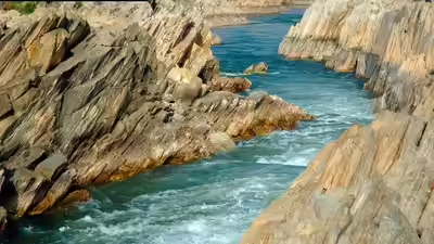
One key factor in this process is the balance between uplift and erosion. When tectonic activity pushes land upward slowly, rivers may be able to erode rock at a similar or even faster rate. Over time, the water cuts deeper into the terrain, forming dramatic gorges that appear as though the river forced its way through solid stone. Advanced dating techniques and satellite mapping now allow scientists to compare rates of erosion with geological uplift, helping them understand how these seemingly improbable landscapes form.
Climate and water flow also play crucial roles in shaping river paths. Regions with heavy rainfall or melting glaciers often have powerful rivers capable of carrying sediment and grinding down rock surfaces. Over thousands or millions of years, this constant movement acts like natural sandpaper, deepening channels and strengthening the river’s established route. Once a deep valley forms, it becomes increasingly difficult for the river to change direction, even if nearby terrain might seem easier to navigate.
Another important discovery involves the composition of the mountains themselves. Not all rock is equally resistant to erosion. Some mountain ranges contain layers of softer sedimentary rock interspersed with harder materials. Rivers may exploit natural weaknesses such as fractures, faults, or less resistant layers, allowing them to cut straight through terrain that would otherwise appear impenetrable. Modern geological surveys using ground-penetrating radar and remote sensing technologies have revealed hidden structural features that guide river courses beneath the surface.
Scientists have also explored the idea of “superimposed drainage,” in which rivers originally flow across relatively flat landscapes that later become more rugged due to erosion or tectonic shifts. As surrounding material wears away, older river channels remain intact and eventually slice through newly exposed mountains. This process helps explain why some rivers appear perfectly aligned with ancient geological patterns rather than current topography.
Computer simulations and advanced mapping tools have played a major role in recent discoveries. By reconstructing ancient landscapes and modeling how water interacts with changing terrain over long timescales, researchers can test different scenarios and identify which conditions are most likely to produce rivers that cut through mountains. These simulations reveal that small differences in climate, rock strength, or tectonic speed can dramatically influence whether a river diverts around a mountain or continues carving directly through it.
Understanding why rivers follow certain paths has practical implications beyond scientific curiosity. Knowledge of erosion patterns and geological stability can help predict landslides, manage water resources, and guide infrastructure planning in mountainous regions. It also helps scientists interpret Earth’s history, offering clues about past climates, tectonic movements, and environmental changes.

Famous examples around the world, from the Indus River slicing through the Himalayas to the Colorado River shaping the Grand Canyon, demonstrate the incredible power of water combined with geological forces. Each landscape tells a story of patience and persistence, showing how rivers and mountains influence one another over immense spans of time.
Ultimately, the question of why some rivers don’t go around mountains highlights the dynamic relationship between water and rock. Rather than choosing an easier path, rivers often hold onto ancient courses, gradually cutting deeper as landscapes rise and shift around them. With new technologies and ongoing research, scientists are finally piecing together these geological puzzles—revealing that the paths of rivers are shaped not just by present terrain, but by millions of years of Earth’s ever-changing history.

